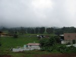
As my time in Glasgow was coming to an end, and since again Anna and I do enjoy a good hike, we asked Anna’s dad if we could stay a few days in his cottage in Lochgoilhead. Thankfully he said yes, and was even kind enough to let us use his truck to get there!! He and his wife also happened to be going when we were planning to go, so we got to spend one of the nights with them:)
Her dad and step-mom were already at the cottage by the time we were able to go, so we took a cab to his house, picked up the truck and headed on out. The drive there was all along normal 2-way lane roads, but just before we got to the turn-off where the road was only 1 lane (for 2 way traffic!!) with the little side pull-offs for people to pass, we stopped for a little lunch… There at the “Rest and be Thankful” landmark we had a bite to eat and I had my first taste of black pudding… Also known as blood sausage… Ick!!! Is all I have to say about that!!! I really didn’t like it at all!! Perhaps it was mainly due to me knowing what it was to begin with, I don’t know… I think it’s just one of those things you have to grow up with to actually like…!!! Anyway the “Rest and be Thankful” stop goes back from quite a long time ago! Those words are inscribed on a stone (see the pictures) placed there by soldiers who built the original military road in 1753. Apparently the original stone was destroyed and replaced by a commemorative stone instead… This point marked the turning point to get to Lochgoilhead. And after our nibble, we headed on to the village where the cottage resided.
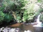
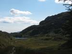
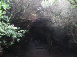
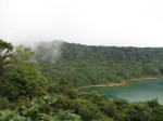
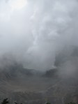
Once we arrived and settled in for a bit, we headed off for our first hike! Again, we aren’t really the kind that prepare the way we should prepare for hikes… Honestly though we didn’t really expect the hike we ended up doing! We simply set out just behind the cottage on a trail that led to some lovely waterfalls! From there we saw some signs pointing this way and that, and thought, why not? So we headed uphill, and up and up… Eventually we came to an area that looked like it could be a good place for a ski slope in the winter! Two older people were coming down the way fully geared in proper hiking attire including ski poles, proper wind pants and hiking boots. As we passed them we stopped them and asked how long to the top? We didn’t get an exact time, but they did warn us about how wet and mucky the way up was and how windy it was at the top, and they further warned us not to go past the stile! We thanked them for their input and headed on our way, figuring that if/when it got too tough for us and our completely inept sneakers/clothing for us to continue, we would turn back!
Up and up we climbed! The slope was pretty decent, nothing really to laugh at by any means and while the land did slosh under our feet (sometimes water did sneak into the sides of my sneakers from the amount of water that pooled from some of the steps) we made it to the stile (don’t cross it!!) in good condition and basically dry.
Once at the stile there really were only two ways to go… Back down or up past the stile… Neither of us was terribly tired at this point and though the view from the stile was nice, you really couldn’t see all the way around because we were surrounded by dense forest on both sides. And since what appeared to be the top of the hill/mountain was just a little ways beyond the stile we thought, heck, why not?? So past the stile we went!
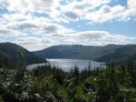
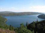
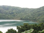
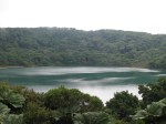
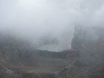
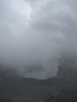
Up and up and up we climbed!! And it was during this hike that I was properly introduced to Scottish hills!!!! You see, what appears to be the top of any hill/mountain in Scotland isn’t at all the top once you actually reach it… For once you get to what you thought was the top, you realize that the top is actually just a wee bit further on… And again just a wee bit further on… And again!!! So literally we went from one “top” to another and another and another until finally what looked like would be the actual top appeared, but by that point it would probably take another hour to get to it and as it was starting to get late in the day (sun was getting lower on the horizon) we opted to give up that mountain top and do the sane and safe thing- turn back toward town! First we had to take some picts of the surroundings and later estimated that we had probably walked about 20-25 kilometers on that hike! We never could actually see on a map where the heck we went, but isn’t that part of the fun?? However, from the position that we made it to, you could see the town below, so we had at least some perspective of where we were!
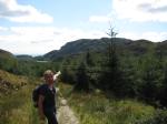
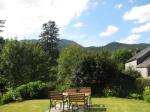
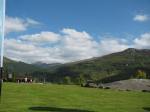
We made it back to town just as the sun was setting, and after a pint in town we headed back to the cottage for a homemade meal! We watched a YES!/No Thanks debate on the tv, then headed to bed (after Anna’s step-mom cleared a rather large spider from our room!!!). The next day we rose at the rear-crack of… about 11am, lol!! Anna’s dad and Step-mom were downstairs with trail maps/paths of the area and they gave input on where we should probably go. We took their advice and around one or so (after packing something to nibble on- how sensible we became!!) headed out again for a hike. Her dad and step-mom joined us for the first half-hour or so of the hike, then headed back while we headed up the trail to the steep/climbing bits.
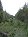
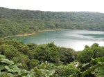
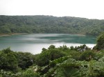
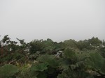
After the hike from the day before both Anna and I were interested and pumped to climb a hill/mountain once again!! And we thought that this particular trail would allow us to do just that… However, the trail never really led to any mountain base. It simply wound around the base of several mountains. Each time we tried to get to a base we were cut off by marshes or terrain so thick with heather/brush that who knew what was under! Finally we did come to the end of the trail that basically dead-ended on the tip of a kind of peninsula. Yet we were still quite determined to get up a hill!! The end of the trail happened to end at the base of a mountain, but the way up was quite steep! Did that stop us?? No, not really… We scaled part of some sheer rock on the side of the mountain up a little way… Then we came to our senses… That we were probably being really daft!! So we gingerly made our way back down. Seriously, the only real way to get up that particular mountain was with proper mountain climbing gear! But again, once at the base we thought surly there MUST be a way up! Anna happened to find a little sheep path, which we followed for several yards until it literally dead-ended at a drop hundreds of feet below us!! Yup, we were being daft in trying to follow the sheep path…
Again we had to give up our quest for the day and headed back. All the while that we headed back we kept looking for ways to get up a dang mountain to no avail! It was probably best though that we didn’t find one… By the time we got back (after a brief scare with some hairy coos- well I wasn’t scared but they are known to be aggressive when babies are around, and as we walked through the field one of the coos spotted us, turned and started walking toward us. I thought it odd behavior and then spotted some baby coos to the right… yea… we hustled a little bit out of that field!) it was almost dark again. We had some drinks and dinner in town then wandered back to the cottage in pitch beautiful darkness!! The kind of darkness where you can see every star!! Just wonderful!! Though Anna was scared out of her wits over walking in the dark and barely let me a few feet away from her, especially when it came time to cross the river, lol!! All in all that day, we estimated we walked about 30-35 kilometers that day! We left the next day and headed back to town (with a brief stop in the lovely town of Luss) where we had a lovely and delicious curry dinner with Anna’s mum! Good times!! 🙂
I almost forgot about the ticks!!! While at the Cottage, Anna’s step-mom left us an article about ticks… Beware the ticks when you hike!! You can get Lyme disease from them!! We laughed it off and didn’t really get bothered by the potential for ticks, though we did check ourselves for the potential of some… I never found any until a few days later when I was in Gatwick!! 4 on my arm!! Ewww… I know!! But they were babies and I plucked them out, watched for signs of Lyme disease, and luckily I can report I’m Lyme disease free!! Yay!!
On to Most Random Street Signs